Pre-colonial and early colonial period
A small bay on the prehistoric shores of Lake Iroquois is the distant ancestor of today’s Vale of Avoca ravine. For thousands of years, this area was part of the traditional lands of Indigenous people, situated close to the ancient walking route connecting the Don and Humber river valleys, on a path that now runs across midtown Toronto.
The area now occupied by David Balfour Park, including the Vale of Avoca and the flat land above it, was used as a hunting ground by the Mississaugas, who maintained the reservoir lands as a prairie in order to attract animals.
During the colonial period several estates were established here. Rosehill was built by Walter Rose in 1839, followed by Summerhill, built in 1843 by two law partners. In 1873 the City acquired the property to build Toronto’s first, and largest ground level reservoir, transforming the Vale into Reservoir Park. The area around the reservoir was maintained as a garden, with many non-native trees and shrubs planted.
The Vale as a Victorian destination park
As Toronto became established, the Vale of Avoca became an important recreational resource for the city, remaining in continuous public use since the mid-nineteenth century.
By 1895 the Vale of Avoca, then commonly known as Reservoir Park, had become a destination park. At the time, the horse-drawn streetcar from downtown Toronto on Yonge Street terminated at Birch, just north of the CPR tracks, at the foot of the steep hill leading to St. Clair. A neighbouring amusement park occupied part of the Summerhill estate and was linked directly to the ravine park.
The park was a popular summer destination, with children playing in Yellow Creek long before the stream was confined by stone retaining walls.
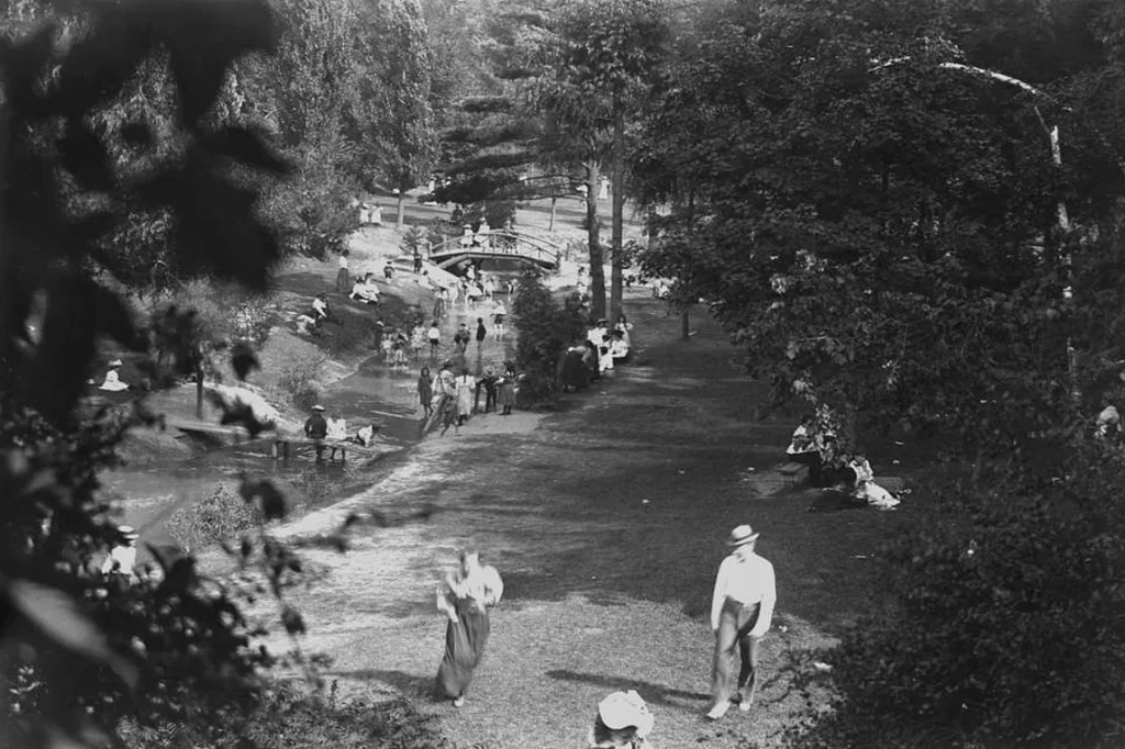
We do not know exactly when the stone-block walls were constructed, but a photograph taken in 1900 of the bridge below Summerhill clearly shows that they had already been built by then.
Bridges across the ravine
The early road network crossed Yellow Creek at two locations, each by a bridge capable of carrying one-way horse-cart traffic.
The northern bridge extended Rosehill Avenue across the creek from what is now the paved service road descending from Avoca. It connected to a road climbing the eastern slope to what is now the intersection of Mount Pleasant Road and Whitehall Road. The original road allowance still appears on City property maps, while the climb up the east side survives today as a pedestrian trail.
The southern bridge connected Summerhill Avenue on the west side of the ravine with what is still called Summerhill Avenue in North Rosedale. Before the construction of the CP Railway in the early 1880s, Summerhill Avenue descended the west side of the ravine to where the creek now disappears underground, crossed Yellow Creek on a wooden bridge, and climbed the east side to Mount Pleasant Road.
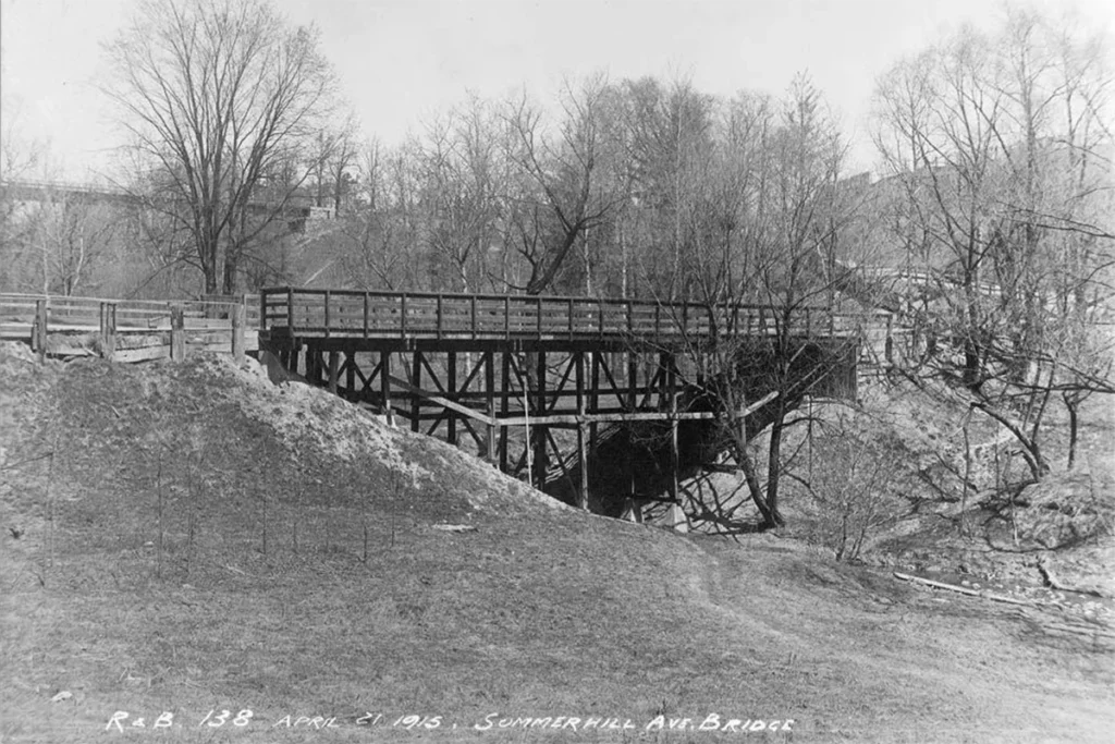
Construction of the railway severed this connection, and both early bridges had disappeared by the early twentieth century.
In 1884, John Moore, developer of Moore Park, built a high-level iron bridge over Yellow Creek connecting Pleasant Boulevard to St. Clair Avenue. It was replaced by the present four-lane St. Clair Bridge in the early 1920s. By then, the only pedestrian crossings remaining were the existing bridge at the bottom of the Avoca service road and the now-lost pedestrian bridge below Summerhill.
The twentieth century
At the end of the nineteenth century, the reservoir was effectively an open lake. Local residents skated on it during the winter, while a walking path around its perimeter connected Summerhill with Avoca and the pedestrian bridge below.
During the Second World War the reservoir was fenced to protect Toronto’s water supply. Between 1964 and 1966, it was deepened and covered, with several concrete-lined ponds, a waterfall, playing fields and gardens constructed above it.
Stone walls that had been built in the late nineteenth century continued to channel Yellow Creek through the Vale. They were designed for the stormwater conditions of the time, when the land north of St. Clair consisted largely of rain-absorbing farmland and urban runoff was far less severe than today.
Yellow Creek today
Yellow Creek is a partially-buried southeasterly tributary of the Don River in Toronto – beginning near the Sheppard West subway station near the former Downsview airport. It angles southeast, mostly buried in underground storm sewers and getting much of its water from the confluence of two former streams at Bathurst Heights and near Briar Hill Avenue. Continuing underground, it crosses Yonge St. and Mount Pleasant Cemetery, finally appearing above ground at the southern protrusion of the cemetery into the Vale of Avoca. It continues above grade until it exits the Vale of Avoca and continues underground as it crosses Mount Pleasant at Park Drive Reservation Road (a road allowance closed in 1973 which now serves as a pedestrian trail).
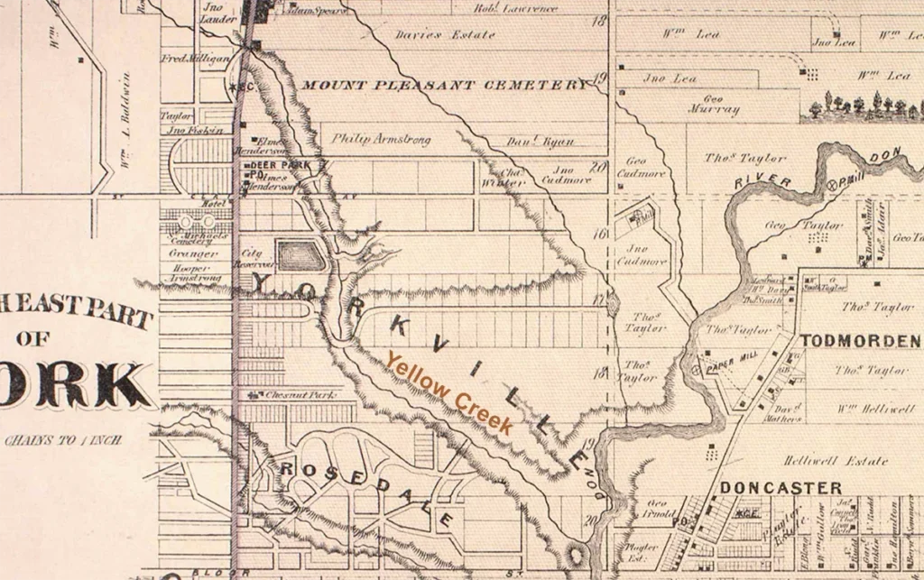
Many people assume that the stream running beside Park Drive Reservation Road is Yellow Creek, but it is not. Yellow Creek has flowed through a large underground pipe beneath the road since the late 1940s, when it was buried from north of Roxborough Drive to the Don River.
The visible stream was constructed during the 1960s as part of the Spadina subway project to carry water diverted from the Cedarvale Ravine. The two streams meet at the foot of Milkman’s Road below Craigleigh Gardens, where they merge before entering a pipe leading to the Don River.
Today and the future
In 2020 the City of Toronto began a major rehabilitation of the reservoir, repairing and upgrading the water system, removing the ponds and waterfalls on top of the reservoir, constructing a new ring trail, improving landscaping, upgrading the washrooms and adding two shade pergolas.
Meanwhile, the ravine itself has received comparatively little attention for decades. Many areas have returned to a relatively untamed state, while erosion, invasive plant species and deteriorating pathways and structures have continued to accumulate.
Preserving and recognizing as much as possible of the ravine’s history, and making it accessible through plaques, displays and interpretation, is one of the aims of our Vision. The ravine also provides valuable opportunities to recognize Toronto’s Indigenous heritage, given its proximity to the Lower Don Wonscotonach Lands and other important historical sites.